
Summary
- Phosphorus is an essential crop nutrient. However, excess soil phosphorus from fertilizer and manure can reach waterways, kill aquatic life and pose human health risks.
- The Risk of Water Contamination by Phosphorus Indicator (or simply, Phosphorus Indicator) measures the risk that farmland phosphorus is reaching waterways and how this risk is changing over time.
- Overall, risk on Canada’s farmland has remained stable over time, though some areas have seen an increase in phosphorus accumulation and potential losses.
- However, risk is high in many areas of Canada because of soil phosphorus build-up, excess application of fertilizer and manure and losses from soil.
- The risk of water contamination by phosphorus can be decreased by reducing residual soil phosphorus and reducing phosphorus losses from soil. Options include improved nutrient management planning, tillage practices and drainage water management and use of cover crops.
Surface water contamination by phosphorus in Canada: why does it matter?
Phosphorus is an essential crop nutrient that is important for crop growth, yield and quality. Phosphorus is present in soils in small amounts because of weathering (minerals slowly breaking down over time) and airborne particles. However, most phosphorus is added to soils through fertilizer and manure.
Excess phosphorus that isn’t used by crops can reach waterways through runoff, tile drainage and leaching through the soil. Phosphorus that reaches waterways can put aquatic systems and human health at risk. High concentrations of phosphorus in fresh water can cause rapid growth of aquatic plants and algae. This can reduce oxygen levels in water, and produce toxins, thereby impairing or killing aquatic life (such as fish, amphibians and invertebrates). For people, these changes result in reduced water quality which can limit bathing, drinking and recreation opportunities. These can have social and economic impacts on the local community.
Many of Canada’s Species at Risk land animals use farmland waterways at some stage in their life cycles. Species at Risk are species that are in danger of disappearing from Canada. To help protect these species, it is important to understand how farming impacts their health and habitat. In some cases, provincial or federal regulations (such as the Species at Risk Act) might also require protection of these species or their habitats.
Proper phosphorus management benefits producers and the environment. Appropriate use of fertilizers can save producers time, resources and money and reduce environmental impacts. The Government of Canada also must report on the risk of water contamination by phosphorus on farmland to determine if farmlands are healthy and where improvements need to be made.
What determines the risk of water contamination by phosphorus?
Ideally, the amount of phosphorus applied through fertilizer would closely match the amount taken up by crops. This would lead to most phosphorus being removed from fields when crops are harvested. However, this rarely occurs for many reasons.
When phosphorus added to the soil exceeds the amount removed from the soil by crops, this results in residual soil phosphorus. Residual soil phosphorus can be high when too much fertilizer is applied and/or phosphorus uptake by plants is low. Uptake by plants can be low when crop growth is low because of drought, floods, pests, pathogens or weeds.
The risk of water contamination by phosphorus is also determined by how much of the residual soil phosphorus reaches waterways. High precipitation can increase phosphorus transport to waterways through tile drainage, leaching out of the crop root zone or surface runoff. Soil type can also be important. Alkaline soils (typical of the Prairies) release more phosphorus into runoff water than acidic soils (typical of Quebec and the Atlantic Provinces).
Climate change is expected to contribute to the risk of water contamination by phosphorus. Excess rain or drought can interfere with crop phosphorus uptake and increase residual soil phosphorus. Excess rain can also increase phosphorus in waterways because of increased runoff or drainage.
Risk of Water Contamination by Phosphorus Indicator
The Phosphorus Indicator shows the amount of phosphorus on farmland and the potential for it to move into waterways. It also measures whether this is changing over time.
To assess this, first, the amount of phosphorus in farmland soil is estimated from the amount of phosphorus already in soil, the amount applied to crops through fertilizer or manure, the amount added from overwintering vegetation and the amount made available through soil erosion. Second, the amount of phosphorus that is removed from farmland soil through crop harvest is estimated. Finally, how much of this phosphorus could reach waterways through surface runoff and tile drainage is calculated. This is estimated based on characteristics of the soil, climate and landscape. The overall risk is scored as very low, low, moderate, high or very high.
The Government of Canada calculates the Phosphorus Indicator every five years to identify how the risk of water contamination by phosphorus on farmland is changing over time. This helps to identify where changes to farming practices are needed.
Risk of Water Contamination by Phosphorus in Canada – current state and change over time
In 2021, areas of high and very high risk occurred in all provinces with the highest risk occurring in Newfoundland and Labrador, Manitoba and Ontario.
Risk of contamination of surface water by phosphorus in Canada in 2021
Between 1981 and 2021, the overall risk in Canada was relatively stable. However, there were some shifts in the amount of farmland in each risk class. The amount of farmland in the low risk class decreased by 12%. This corresponded with increases in the amount of farmland in the high risk class (from 5.2% to 9.6%) and in the very low class (from 23% to 30%).
Change in phosphorus risk, 1981 to 2021
Regional trends
British Columbia
Risk has remained stable in most of British Columbia; however, risk has increased in the southern part of the province and has decreased in the central part of the province. Areas of high and very high risk occur in the southwest where there are high livestock concentrations.
The Prairies
Areas of high or very high risk occur in southern Manitoba, and east-central Saskatchewan and Alberta. While risk has remained relatively stable over time in Manitoba, risk has increased in much of Alberta and Manitoba. There was a noticeable increase in the amount of high risk farmland in Alberta, which went from 2.5% to 9.67%, and Manitoba which increased from 0% to 28%. Areas of highest risk are caused by high livestock densities and increased fertilizer application. Increased fertilizer use could have been caused by the transition from a summerfallow system to one of continuous cropping.
Ontario
Areas of high and very high risk occur in most of southern Ontario caused by high amounts of manure and fertilizer application. However, risk has declined in some areas of southern Ontario as well. In fact, since 1981, the amount of farmland in the very high risk class has decreased from 36% to 27%. The phosphorus balance (the amount of phosphorus remaining in soil) has declined steadily over this time as well from 9.9 kg/ha to 1.9 kg/ha.
Quebec
Areas of high and very high risk occur in southeastern Quebec along the St. Lawrence River due to high amounts of manure and fertilizer application. Since 1981, the phosphorus balance has declined steadily from 14% to 7%. The amount of farmland decreased in the low category from 37% to 23% and moderate from 40% to 29%. Conversely, the amount of farmland increased in the high classification from 10% to 26% and very high increased from 9% to 17%.
The Atlantic Provinces
Most of the Atlantic Provinces have low or moderate risk. Areas of high and very high risk occur in Prince Edward Island and western New Brunswick. This is caused by high livestock concentrations in New Brunswick and high erosion and fertilizer use for potato production in Prince Edward Island. Since 1981, the phosphorus balance has declined steadily from 21% to 16%. A large spike in the phosphorus balance in 2021 is thought to be from data inaccuracies. Despite this, in many areas, risk has shifted from low and very low to moderate and high.
How can water contamination by phosphorus be reduced?
While the risk of water contamination by phosphorus in Canada has remained stable since 1981, risk is still high in many areas. The main driver of risk is the buildup of phosphorus in agricultural soils and high levels of manure and fertilizer use.
Some strategies for reducing risk, outlined below, include reducing residual soil phosphorus levels and reducing phosphorus losses from soil.
Reducing soil phosphorus
- Implement a “4R” nutrient stewardship plan to ensure efficient phosphorus fertilizer application: the right source of fertilizer, applied at the right rate and time and in the right place.
- Use soil and plant-tissue testing to determine the optimal fertilizer rates.
- Use precision feeding practices to reduce pockets of high phosphorus from manure.
- Transfer manure from livestock to crop farms to reduce local manure surpluses.
- Include high nutrient-use efficiency crops in rotation with low nutrient-use efficiency crops (for example root crops).
Reducing phosphorus losses from soil
- Adopt reduced tillage practices.
- Plant cover crops following high-disturbance crops (for example, potato, carrot).
- Manage drainage water. This can be achieved in irrigation systems or using controlled drainage systems on tile-drained land.
- Use nature-based solutions, such as wetlands and vegetative filter strips, to capture edge of field losses.
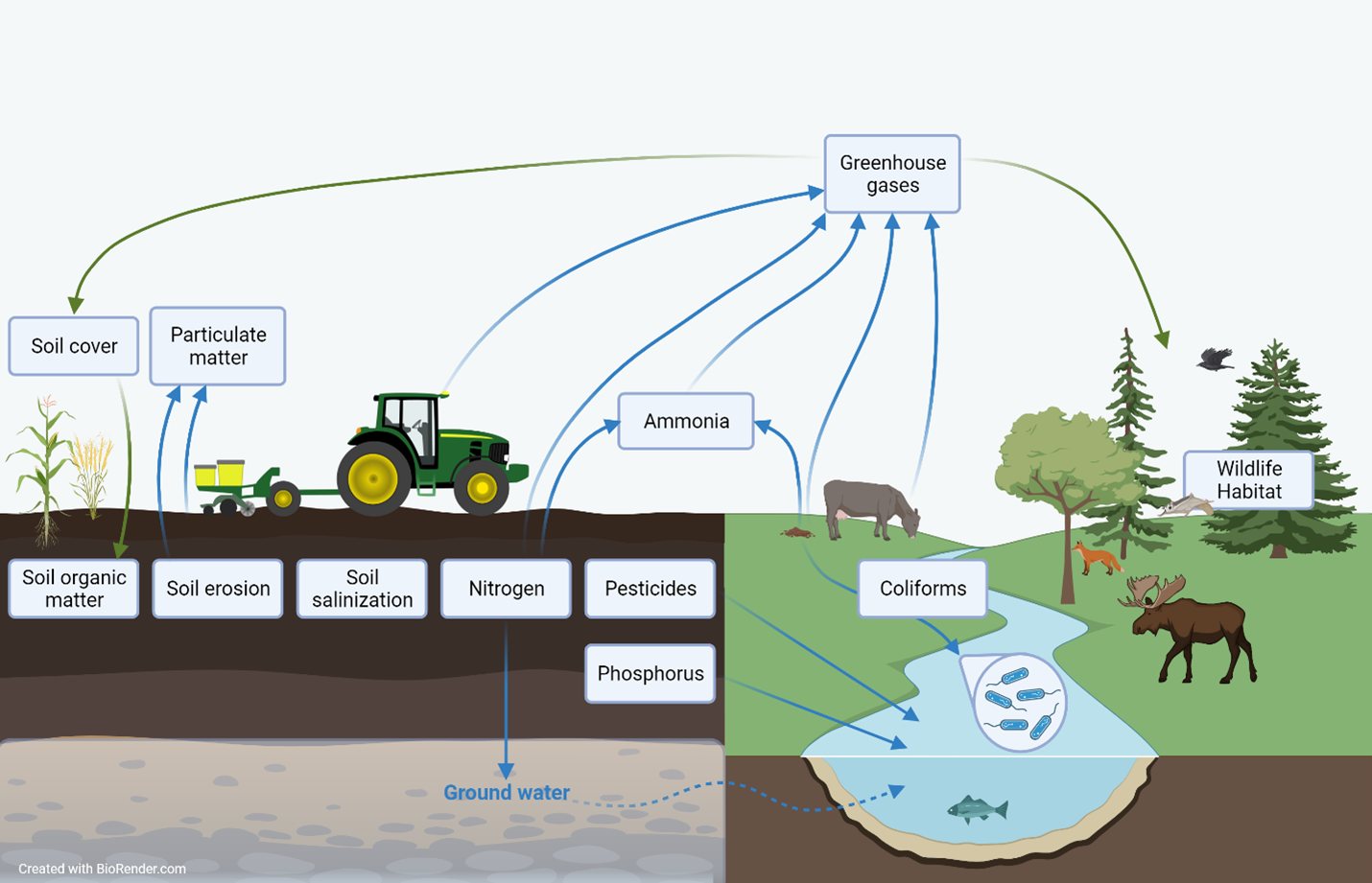
Description of the image above
An infographic showing an agricultural landscape with crops, a tractor, soil and grazing livestock adjacent to a natural landscape with a watercourse, forest and wild animals. Info boxes are placed to show to which element of the landscape each agricultural sustainability indicator pertains. Arrows connect some of the info boxes to show interrelationships. One info box is present for each of the following indicators: Soil cover, particulate matter, soil organic matter, soil erosion, soil salinization, nitrogen, pesticides, phosphorus, ammonia, greenhouse gases, coliforms and wildlife habitat.
Agriculture and Agri-Food Canada's agri-environmental indicators (AEIs) provide a science-based snapshot of the current state and trend of Canada’s agri-environmental performance in terms of soil quality (soil organic matter, soil erosion, soil salinization), water quality (nitrogen, pesticides, phosphorus, coliforms), air quality (particulate matter, ammonia, greenhouse gas emissions) and farmland management (agricultural land use, soil cover, wildlife habitat). While indicator results are presented individually, agro-ecosystems are complex, so many of the indicators are interrelated. This means that changes in one indicator may be associated with changes in other indicators as well.
Learn more
Additional resources and downloads
Discover and download geospatial data related to this and other indicators