
On this page:
What is a Watershed?
A watershed is the area of land that drains into rivers and lakes, which, in turn, flow to a common outlet. Groundwater discharge is included in the watershed, although boundaries may not coincide exactly with surface water. Smaller drainage areas that feed into sub-watersheds, may be referred to as drainage basins or catchments. Watersheds may also drain into river basins, which can encompass larger areas.
Established watersheds are separated from one another by the height of the land, also known as drainage divides. Drainage divides are said to delineate the watershed.
Watersheds are nested systems, with smaller ones nesting into larger ones. The streams that form watersheds can be classified by an ordering framework. For example, headwater streams, which are at the highest elevation in the watershed, are first-order streams.
When two first-order streams join they become a second-order stream. And when two second-order streams join they form a third-order stream. A stream joined by a lower-order stream remains the same order. For example, a third-order stream joined by a first-order or second-order stream remains a third-order stream.
There is a close relationship between drainage patterns in a watershed and the underlying sediment or bedrock. Structural features such as faults and fractures can also influence the drainage pattern.
Each watershed is unique. Characteristics include, but are not limited to, the total area of the watershed, its shape, the arrangement of slopes and the overall relief or elevation change. Additional characteristics include the form of its drainage network, the types and arrangement of vegetation cover, the nature of the soils, the geology, and land-use patterns.
To gain a good understanding of how these various characteristics interact, it is important to have access to climactic data, agricultural practice information, hydrological data, environmental data, aerial photos, topographic maps, and geological maps.
Other useful information includes soil maps, water resource and water quality data, land zoning and land use data, forestry maps and data, vegetation maps, water rights and wastewater disposal data, and aquatic and terrestrial habitat data.
Watershed management is a continuous process. It requires a multi-disciplinary approach, the use of sound science, and the implementation of well-planned actions to achieve specific physical objectives.
The goal is to enhance and protect our water quality and environmental health on an individual/ watershed basis. We know that improving land management practices upstream can often maximize water quality and availability downstream. There are numerous beneficial management practices (BMPs) designed to mitigate human impacts originating at upstream locations. Impacts to headwaters can affect current or future watershed function, resources and usage.
The physical boundaries of watersheds seldom coincide with political boundaries, administrative planning or management units; therefore, a significant part of watershed management involves balancing competing interests and resolving conflicts between upstream and downstream users of the resource. Conflicts can arise when upstream users appear to bear the costs while downstream users reap the benefits.
Delineating a Watershed
The physical boundaries of watersheds can be mapped and analyzed. Defining a watershed in terms of its area is useful for determining the land-use activities within its boundaries, for calculating runoff volumes and contaminant loads, and determining the multiple government jurisdictions, businesses and individuals who have a stake in environmental health.
Digital Elevation Models
A Digital Elevation Model is a three-dimensional representation of a topographic surface. They can be particularly useful for determining flow directions within a watershed.
Watershed Hydrology
Any dynamic system has inputs, outputs and storage as prominent features. In watershed hydrology these are expressed as precipitation, interception, surface storage, evapotranspiration, infiltration, runoff, interflow, and groundwater flow.
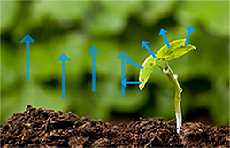
Description of the image above
Small plant growing in soil. Plant leaves have arrows pointing upwards to show transpiration by the plant. Arrows are also pointing upwards from the soil to show evaporation by the soil
Precipitation falls as rain or snow. Some of it is intercepted by vegetation cover and never reaches the ground. Some of it runs off to become surface water, and may be stored in ponds and lakes. Some infiltrates the soil, where it may be taken up through the root systems of plants for use in transpiration.
Evapotranspiration includes moisture evaporated from the soil as well as transpiration by plants. Interflow is lateral flow through the unsaturated soil zone above the water table. The water table is the top of the saturated zone from which groundwater, that is held in pores or fractures, can be extracted.
Evaporation from surface water bodies combined with evapotranspiration completes the water cycle. It is important to note that groundwater contributes important base flow to streams and lakes.
The water balance is the state of equilibrium in the drainage basin between the inputs and outputs. It can be expressed as P = R + E, plus or minus changes in storage, where P is precipitation, R is runoff, and E is evapotranspiration.
Watershed characteristics affecting runoff include watershed size, shape, and stream order. They also include topography, geology and soil types, which in turn influence infiltration characteristics and erosion potential. Cultural features, agricultural practices, and residential development also have to be taken into account, as do in-stream structures, dams, and hydrologic modifications.
In addition to the type of soil, its porosity, permeability, and degree of compaction, some of the factors that influence infiltration capacity include: topography, slope angle, rainfall intensity and duration, antecedent or preceding soil moisture, geology, temperature, vegetation amount and type, and land use practices.
Field observations and measurements required for an accurate analysis of a watershed's hydrology include the topographic setting and a description of streambed material. Is the setting hilly or flat? Does the stream have a silt bed or are there cobbles? Are there depositional or erosion features such as point bars or undercut banks? Are there water intakes withdrawing water and/or outfalls discharging wastewater into the stream? Are the stream banks stable or is there evidence of excessive erosion? Is the stream narrow and deep, or wide and shallow? Is the stream gradient steep as in a mountain stream, or does it lazily meander across a floodplain?
Field observations and dimensions important in stream flow measurement include the following:
- The cross-sectional area of the stream channel, which is its width multiplied by its height.
- The wetted perimeter, which is the width of the bed that is submerged at high water.
- The hydraulic radius, which is the cross-sectional area divided by the wetted perimeter-the greater the hydraulic radius, the more efficient the channel is at moving water and sediment.
- The stream stage is the height of water in the channel, which varies over time. For example, is the river at flood stage?
- The velocity is the speed at which water is flowing in the channel, usually expressed in feet per second or metres per second.
- Stream discharge is the volume of water flowing in the channel, usually expressed in cubic metres per second (cms) or cubic feet per second (cfs).
Streamflow gauging determines the discharge or volume of water per cross-section of stream per time interval at a given location. Gauging requires a number of observations or field measurements to collect adequate amounts of data.
Streamflow data includes water level or stage, flow rate or flow velocity, flow volume, and water quality characteristics. A time series, which will give a more complete picture of stream flow, is a set of measurements taken at regular time intervals. It may be recorded continuously or be event-based during times of floods or low flows.
Flow regime classifications are based on the degree of continuity of the stream flow and reflect the influence of climate factors. There are three types of streams. A perennial stream never ceases to flow, an intermittent stream flows only part of the year, and an ephemeral stream flows only after a rain event.
Surface versus Groundwater
We commonly make a distinction between two types of water: groundwater and surface water. Groundwater chemistry is often more predictable than surface water chemistry because it doesn't change over time or over space as quickly as surface water. Surface water generally has fewer dissolved solids because surface water includes a significant component made up from precipitation that hasn't had a long enough time in contact with minerals to have a high dissolved mineral content.
Groundwater is usually more alkaline than surface water. Surface water may range in hardness depending on its sources of water, whereas groundwater is usually either soft or hard, depending on its age. Surface water is usually higher in nutrients than groundwater except in bedrock-predominated areas like the alpine and the Canadian Shield regions. In addition, surface water generally has much higher concentrations of organisms because of higher nutrients and the presence of sunlight which promotes primary production, and is the base of the food web.
| Surface Water | Groundwater |
|---|---|
| Low Total Dissolved Solids (TDS) | High TDS |
| Less alkaline | More alkaline |
| Soft – hard | Soft or hard |
| Low – high in nutrients | Low in nutrients |
| Low – high in organics | Low in organics |
Groundwater Systems
The groundwater aquifers that feed surface water systems are sometimes described as local or regional groundwater systems. Local groundwater aquifers are generally shallow and are recharged primarily from the uplands surrounding the surface water system. Regional groundwater aquifers are generally deeper, much larger and are recharged by a much broader landscape than local aquifers.
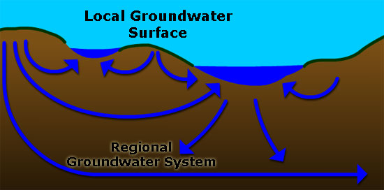
Description of the image above
Cross section showing how local groundwater flow is the water that flows near the surface of the ground and regional groundwater is the water that flows deeper underground.
Surface Water Systems
Surface water systems are divided into lotic and lentic systems.
Lotic refers to flowing water systems. These systems are strongly influenced by water movement which flows predominantly in one direction. They are very dynamic in that they are constantly changing due to erosion and deposition. Lotic systems are adapted to great changes in water level and, in general, will have high dissolved oxygen concentrations.
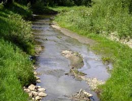
Lotic system = flowing water system
Lentic refers to standing water systems. In these systems, light and wind are the dominant physical processes that affect the chemistry and biology of the system. They are primarily depositional habitats.
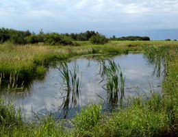
Lentic system = standing water system
Spatial and Temporal Variation
The properties of a water body can vary greatly between different areas and depths. As well, these characteristics can be expected to vary over the course of a year and even within the time span of a single day.