
The following maps of the Central Experimental Farm (CEF) identify boundaries, buildings and sites of interest on the Farm.
Maps of the Central Experimental Farm (PDF Version, 6,119 KB)
Central Experimental Farm - Building Area Map
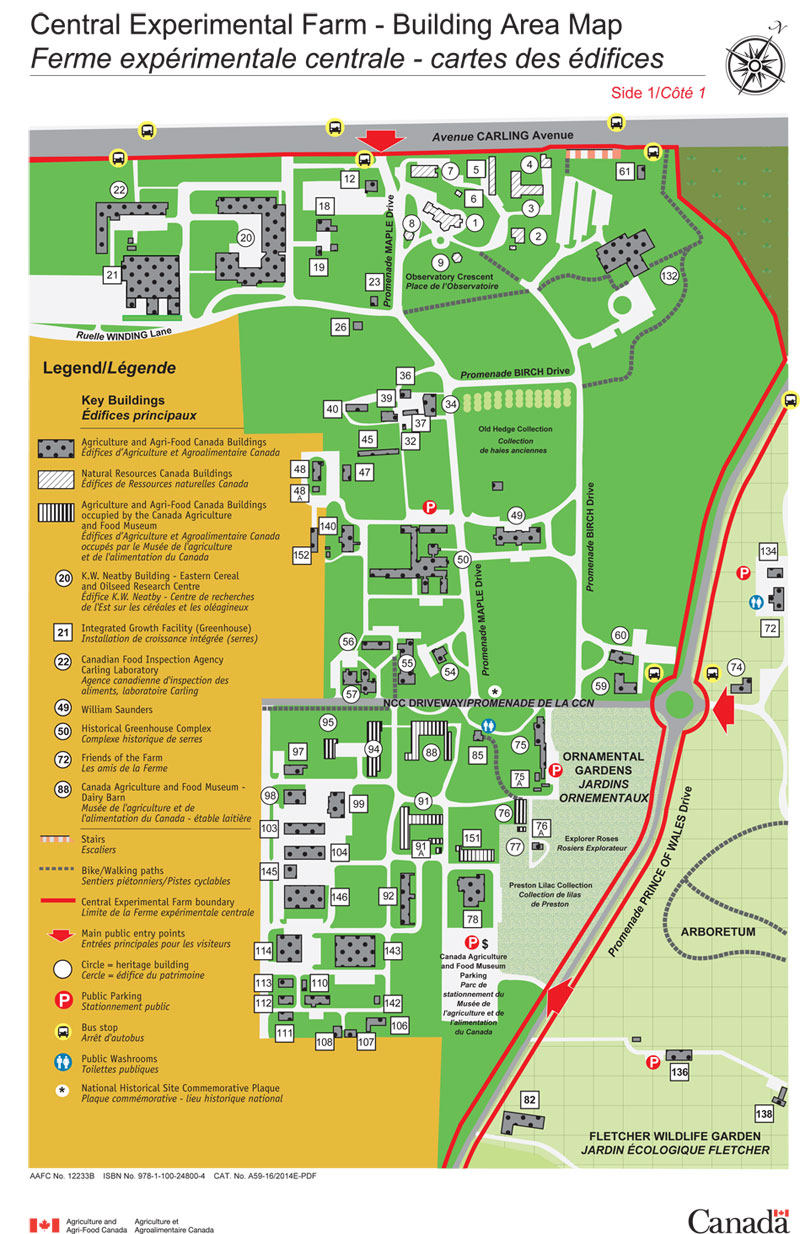
The Building Area Map identifies buildings 1 to 153. The key buildings are:
- Buildings 1 to 9: Natural Resources Canada Campus
- Building 20: K. W. Neatby Building Eastern Cereal and Oilseed Research Centre (Heritage Building)
- Building 21: Integrated Growth Facility (Greenhouse)
- Building 22: Canadian Food Inspection Agency Carling Laboratory (Heritage Building)
- Building 49: William Saunders (Heritage Building)
- Building 50: Historical Greenhouse Complex (Heritage Building)
- Building 54: Heritage House (Heritage Building)
- Building 55: Horticulture Building (Heritage Building)
- Building 59: Nutrition Building (Heritage Building)
- Building 60: Heritage House (Heritage Building)
- Building 75: Cereal Building (Heritage Building)
- Building 88: Canada Agriculture Museum - Dairy Barn (Heritage Building)
Central Experimental Farm Site Map

Description - Central Experimental Farm Site Map – Side 2
This map presents the following elements:
- Agriculture and Agri-Food Canada Buildings
- Natural Resources Canada Buildings
- Agriculture and Agri-Food Canada Buildings occupied by Canada Agriculture Museum
- Principle Roads
- Internal Roads/Paved areas
- Lawns
- Ornamental Gardens
- Arboretum/Fletcher Wildlife Garden
- Research fields
- National Headquarters Complex for the Agriculture Portfolio
- Stairs
- Bike/Walking paths
- Central Experimental Farm Boundary
- Railroad
- Main public entry points
- Building Identifier and Number
- Heritage building Identifier and number
- Public parking
- Bus stop
The Farm Site Map shows the three roadway borders of the CEF to assist users traveling to the site by the City of Ottawa road network.
Boundaries
- Northern: Carling Avenue
- Western: Fisher Avenue and Merivale Road
- Southern: Baseline Road
- Eastern: Rideau Canal
The National Headquarters Complex for the Agriculture Portfolio is situated at the western gateway of the CEF. It is located in the southwest corner (map lower left) of the CEF property across Merivale Road from the ECORC research fields.
Most of the CEF property comprises the research fields and crop testing plots for the plant breeding and agronomy programs of the Eastern Cereal and Oilseed Research Centre. Internal roadways allow vehicle access for field operations.