
Source: Mikael Guillou (MAPAQ)
Soil erosion and inadequate surface drainage greatly reduce the productivity of agricultural fields and can cause water quality problems downstream from the affected fields.
This page presents erosion and surface drainage problems frequently observed in fields as well as the hydro-agricultural installations and cropping practices most appropriate to each situation. Essentially, the proposed solutions are aimed at:
- reducing the volume and flow of runoff water;
- modifying the slope of the land, and intercepting and directing the surface runoff in order to reduce its speed; and
- improving soil structure, and protecting the surface to increase its resistance to erosion.
Sheet erosion
Sheet erosion
Source: Richard Laroche (MAPAQ)
The uniform-or non-concentrated-flow of water on the surface of the soil can rip up and drag fine particles that are then transported towards watercourses. This type of erosion is called sheet erosion. Because of its diffuseness, this type of erosion is difficult to detect, but it can cause significant soil losses. All soil types can, to varying degrees, be affected by sheet erosion. The adoption of preventive measures can to a great extent prevent this problem from appearing.
Diagnosis - Sheet erosion
The areas affected by sheet erosion can be identified by lower yields and paler soil colour, as well as by eroded-material deposit sites when benches are located downstream. Eroded zones have thinner topsoil than the other parts of the field.
Solutions - Sheet erosion
Sheet erosion can be prevented with cropping practices such as:
- establishing a good vegetation cover;
- maintaining a significant portion of crop residues in the soil through reduced tillage; and
- adopting balanced rotation (with grasslands or green manure catch crops or intercropping).
These practices limit and slow down surface runoff by increasing the roughness and infiltration potential of the soil. Moreover, they improve soil structure and, in so doing, its resistance to erosion.
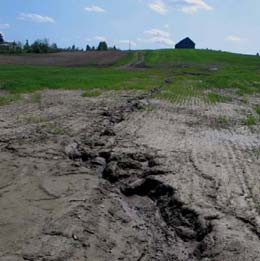
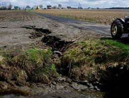
Field gullying

Small gullying
Source: Jacques Goulet (MAPAQ)
When draining water picks up speed and is concentrated in certain drainage canals, it can erode large quantities of soil in these canals, thereby creating runnels or ravines.
Diagnosis - Field gullying
A soil surface examination can help detect the affected areas, particularly after periods of heavy rains or during snow melt. Before appropriate solutions can be selected, the causes of the gullying must be identified. The sudden appearance of a gullying may be the result of, among other things, a change in the way the soil is being used upstream or particular weather conditions. In spring, the low infiltration capacity of frozen soil can promote the appearance of runnels and ravines in the fields.
Solutions - Field gullying

Significant gullying
Source: Mikael Guillou (MAPAQ)
First of all, runnels can be dealt with through normal tillage operations, while ravines are bigger and must be backfilled, with care taken to protect the topsoil.
In the case of small gullyings, a change in cropping practices can sometimes resolve the problem. The best practices are the implementation of forage crops, reduced tillage or direct seeding, and cross-slope cropping. If the cause of the surface runoff is located further upstream in the drainage basin, selective reforestation of this area can also be a good solution. Levelling work can help limit the erosive nature of the surface runoff.
When there are significant gullyings, the practices mentioned above are still recommended, but adapted structures must also be put in place in a more targeted manner. In areas of concentrated surface runoff where the water drains away quickly, gullyings can be avoided by installing a grassed (or rip-rapped) watercourse. When gullyings are caused by a sudden and relatively brief increase in the slope of the field, a system with an inlet well and berm can be put in place to create a retention pond and drain away surface runoff through underground piping in order to reduce surface flow in the areas that are more prone to erosion. This type of system also makes it possible to promote sedimentation of the soil particles suspended in the surface runoff before the runoff is drained, but good water storage capacity in the field is required. There is also a risk in using berms, in that a berm failure could cause serious damage downstream.
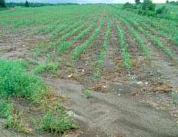
Poor drainage of depressions
The poor drainage of depressions often causes a delay in working the fields. Furthermore, work is often undertaken before the depressions are completely dry, resulting in compaction problems and a worsening of drainage problems in these zones (Figure 1). Lastly, when depressions filled with water drain in an uncontrolled manner, they can cause gullying problems.
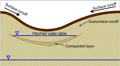
Description – Figure 1
This diagram shows that there is a compacted layer of earth below the surface of a depression which does not allow proper drainage and holds a perched water table that is continually being filled by surface and subsurface runoff.
Diagnosis - Poor drainage of depressions

Poorly drained depression
Source: Mikael Guillou (MAPAQ)
A visual examination of the land is performed to identify the eroded depressions and zones, especially after periods of heavy rain or in the spring, after the snow has melted. However, a depression is often much bigger than the portion of the field that is flooded after precipitation. The exact size of the depressions must be determined by a detailed topographical report. An analysis of the drainage plan is also essential to the selection of appropriate solutions.
Solutions - Poor drainage of depressions
If the depression is limited in size, it can be eliminated through levelling (maximum area of the depression based on the topographical report: 0.5 hectares; maximum depth: 5 to 10 centimetres. The work must be done with great precision, because insufficient levelling could result in expanding the area of the depressions. The final slope of the land must be at least 0.15%, so as to avoid any water accumulation above the old depressions. Furthermore, the topsoil must be kept at the surface in all circumstances. Lastly, it is sometimes necessary to undertake corrective work during the first few years following the levelling, in order to eliminate the irregularities that might result from soil compaction following the work.
If the depression is too large to be levelled, there are several possible solutions. An infiltration well or a permeable trench can be used to drain the accumulated water from depressions that are too deep to be backfilled. Infiltration wells are good for small, circular depressions (with a maximum area of approximately 0.5 hectares), while permeable trenches are better suited to elongated depressions. These structures reduce soil losses and are not an obstacle to machinery.
Another solution is the construction of a grassed waterway. This type of structure is easy to construct, but it does lead to a loss of cultivable area in the field and requires frequent maintenance, because the grassed area does not withstand the frequent movement of machinery and the spraying of herbicides well. However, grassed waterways are the only possible option when a deep enough outlet is not available to service a structure that requires the installation of a drain outlet.
Inlet wells make it possible to drain large depressions (up to 20 hectares). However, they are an obstacle to machinery and, when installed in the middle of the field, must be clearly marked so that they can be easily found. Soil losses can be reduced further by limiting the speed at which the water drains; doing so promotes the sedimentation in the field of the soil particles in the surface runoff.
Resurgence of subsurface runoff or unconfined groundwater
Water can travel at shallow depths under the surface of the soil, in the direction of the field slope. This water is called subsurface runoff, and it sometimes resurfaces at the bottom of depressions (Figure 1), at the bottom of slopes, or in slopes if they are very long or have benches (Figure 2). Unconfined groundwater can also rise to the soil surface (as a spring) when the subsoil is irregular (Figures 3 and 4). These resurgences can lead to compaction and erosion problems if the flow is not controlled.
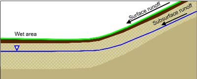
Description – Figure 2
This diagram shows that surface runoff as well as subsurface runoff follow the field slope leaving a wet area at the bottom.
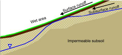
Description – Figure 3
This diagram shows that when the impermeable subsoil rises irregularly, the subsurface runoff rises as well and may reach the soil surface at which point the surface and subsurface runoff cause a wet area.
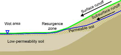
Description – Figure 4
This diagram shows that when subsurface runoff runs from permeable soil and reaches low-permeability soil there is a resurgence zone where the surface and subsurface runoff meet and rest above the low-permeability soil causing a wet area.
Diagnosis - Resurgence of subsurface runoff or unconfined groundwater
Subsurface runoff or unconfined groundwater resurgence zones are characterized by the fact that they are often damp even though they are not located in depressions. This last point is important because, since Quebec fields often have low slopes, resurgence zones can sometimes be difficult to distinguish by the naked eye from depressions. That is why it is important to review the topographical report in detail to make a well-informed diagnosis. Soil profiles can also help identify the precise cause of the resurgences.
Solutions - Resurgence of subsurface runoff or unconfined groundwater
Grassed waterways are simple, low-cost structures for draining water from the resurgence of subsurface runoff or unconfined ground water. They are used infrequently, because they generate a loss of space, complicate field work and require frequent maintenance. However, grassed waterways are the only possible solution when there is no outlet deep enough to service a structure that requires the installation of a drain outlet.
The most common solution for eliminating resurgences is the installation of an interceptor drain along these zones. This solution works particularly well in permeable soils, such as sandy or well structured clay soils. In less permeable soils, infiltration wells or permeable trenches can complete the system to increase infiltration, depending on whether the resurgences are localized (wells) or linear (trenches).
Erosion at confluences

Erosion at the confluence
of a ditch and a watercourse
Source: Mikael Guillou (MAPAQ)
The confluences of ditches, runnels and furrows are often prone to erosion, since the runoff volume and flow are significant in those spots. This erosion is accentuated by differences in elevation that can exist between the tributary and the outflow.
Diagnosis - Erosion at confluences
The deposition of sediment in the outflow is a good indicator of this type of erosion.
Solutions - Erosion at confluences
Depending on the case, erosion at confluences can be controlled by installing a grassed chute, a rock chute or a drainage ditch.
A grassed chute is created by installing sod at the mouth of the furrow or the runnel to be protected. A grassed chute is the simplest and least costly solution and can be applied in cases where the flow is weak and slow.
A rock chute involves strengthening the confluence using riprap and a geotextile membrane. A rock chute can withstand higher water speeds than a grassed chute. However, a rock chute does not increase sedimentation in the field.
A drainage ditch is constructed by backfilling the mouth of a ditch to create a sedimentation basin with a rip-rapped overflow, from which the water is drained using an inlet well and high-density polyethylene (HDPE) piping. This structure is more complex and more costly to install than a rock chute but has the advantage of promoting sedimentation in the ditch and facilitating the movement of machinery between fields.
Bank gullying
Bank gullying
Source: Mikael Guillou (MAPAQ)
Like confluences, the banks of watercourses are zones where the risk of erosion is high, because of the concentration of surface runoff and the difference in elevation between fields and watercourses.
Diagnosis - Bank gullying
The gullying and sediment deposition zones in watercourses are easily identifiable and make it possible to identify the sections to be stabilized.
Solutions - Bank gullying
Systems with rock chutes and berms or inlet wells and berms can be used to protect the banks and concentrate the surface runoff towards a protected drainage point. A rock chute works well in cases where the length and inclination of the banks are limited. An inlet well can be used in cases where sedimentation in the field is to be promoted. As explained in the "Field Gullying" section, the sizing, construction and maintenance of berms must be conducted with particular care, given the damage that the failure of a berm can cause downstream.
Erosion and poor surface drainage can have a significant negative impact on crop productivity and surface water quality. A good diagnosis will make it possible to select the solution that is best suited to the problem observed. Lastly, healthy soil, characterized by good structure and active organic matter, will withstand erosion better. Think about it!
Summary table
| Problem | Solutions | Comments |
|---|---|---|
| Sheet erosion |
|
These practices should be adopted as preventive measures in all fields where they are applicable |
| Field gullying | Forage crops, reduced tillage or direct seeding, cross slope cropping, selective reforestation upstream from the field, levelling | Use when the surface runoff is significant and the flow is rapid |
| Field gullying | Grassed (or rip-rapped) watercourse | Use when the surface runoff is significant and the flow is rapid |
| Field gullying | Inlet well and berm |
|
| Poor drainage of depressions | If the depression is small: Levelling | For small depressions (maximum area = 0.5 hectare; maximum depth = 5-10 centimetres) |
| Poor drainage of depressions | If the depression is too large and/or too deep to be levelled: Infiltration well or permeable trench |
|
| Poor drainage of depressions | Grassed waterway |
|
| Poor drainage of depressions | Inlet well |
|
| Resurgence of subsurface runoff or unconfined groundwater | Grassed waterway |
|
| Resurgence of subsurface runoff or unconfined groundwater | Interceptor drain | Particularly effective in permeable soils |
| Resurgence of subsurface runoff or unconfined groundwater | Infiltration well or permeable trench |
|
| Erosion at confluences | Grassed chute | Simple, adapted to low flow speeds |
| Erosion at confluences | Rock chute | Simple and resistant, but does not promote sedimentation |
| Erosion at confluences | Drainage ditch |
|
| Bank gullying | Rock chute with berm |
|
| Bank gullying | Inlet well with berm |
|
References
Brunelle, A. et V. Savoie. 2000. « Problèmes de drainage ». Feuillet 7-B in Guide des pratiques de conservation en grandes cultures. Conseil des productions végétales du Québec inc. (CPVQ). In partnership with: Canada Quebec Subsidiary Agreement on Environmental Sustainability in Agriculture; CPVQ; FPCCQ; MAPAQ; MENV; Agriculture and Agri-Food Canada Document containing 7 modules and 34 sheets.
Conseil des Productions végétales du Québec. 1976. Drainage souterrain - Information générale. Agdex 555, Ministère de l'Agriculture du Québec, 40 pages.
Centre de référence en agriculture et en agroalimentaire du Québec. 2005. Guide de référence technique en drainage souterrain et travaux accessoires. Publication No VY 006, Sainte-Foy, Québec, 68 pages.
Ministère de l'Agriculture, des Pêcheries et de l'Alimentation du Québec. 1990. Normes de conception et d'exécution pour les travaux de conservation et gestion du sol et de l'eau. Publication interne.
This content was prepared as a result of a partnership between Agriculture and Agri-Food Canada and the Ministère de l'Agriculture, des Pêcheries et de l'Alimentation du Québec (MAPAQ).