Introduction
Before the prairies were developed for agricultural crop production, an abundance of natural wetlands were an integral part of the prairie grassland and parkland ecosystems. While there is considerable uncertainty about wetland loss, up to 70% is estimated in settled areas across Canada (Source: Canadian Wetland Inventory, 2008), and 84% of this loss is attributed to drainage for agricultural crop production (Source: Canadian Wildlife Service, 1991).
Remaining wetlands within fields used for agricultural production often pose significant challenges for farmers. At the same time these wetlands provide many important ecosystem functions. Over the past several decades a growing number of environmental programs have encouraged farmers to restore and/or maintain natural wetlands. These programs have been somewhat successful in some areas, but in other areas wetland drainage continues.
Wetland management is a prime example of where ecological and agricultural perspectives are often widely divergent. However, the reality is that ecosystem function and agricultural production have coexisted on the prairie landscape since cultivation began, and will continue to do so in the future. The challenge is to design land management systems that allow both of these outcomes to flourish. This publication seeks to provide information and recommendations that lead to optimal benefits from a proper balance of ecosystem function and agricultural production.
Understanding Natural Wetlands
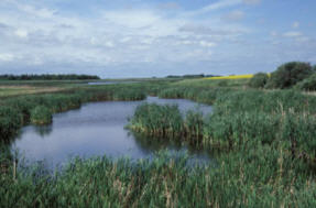
Wetlands are typically low lying areas impacted significantly by water at or near the surface. They include not only open water bodies such as sloughs and springs, but also the riparian area immediately upslope of water bodies.
The riparian area, simply defined as the interface between land and water, consists of different zones characterized by varying degrees and persistence of water ponding or soil saturation. A common feature of these zones is that they support water loving organisms. These zones are typically organized as concentric circles or bands, each with a unique set of organisms adapted for their specific environment. Plant species include both vegetative and woody types, and most are perennial.
The size of the wetland pond and its surrounding vegetation zones fluctuate over seasons and year to year due to wet and dry cycles. However, organisms adapted to wetlands have the capacity to move laterally up or down the slope as required. Many are also able to create "seed banks" that remain dormant when conditions are not conducive to growth, but flourish when conditions improve (Source: Leck, 1989). As a result natural wetlands, while never static, are able to remain healthy under changing environmental conditions.
Natural wetlands provide a number of valuable ecological functions. Most obviously these areas have tremendous biodiversity, as they typically contain the greatest number and populations of species in the landscape. They also provide habitat for a large number of animal species that move in and out of wetland areas from surrounding uplands. In addition wetlands also help to:
- maintain water quality by filtering nutrients and pesticides, trapping sediment, and stabilizing shorelines and stream banks from erosion
- buffer water supplies by holding water during droughts, releasing water slowly to avert flood damage and recharging ground water aquifers.
- reduce greenhouse gases by building and storing soil carbon
Drainage of Wetlands
Drainage of wetlands on the Canadian prairies is usually achieved by altering surface flow, rather than increasing subsurface flow through tiles. In most cases this involves lowering the elevation of the surface outlet and altering the downstream waterway through channelization or ditching. Surface drainage is considerably less expensive than tiles, and more suited to prairie landscapes where cropping systems are considerably less intensive.
The current level of drainage projects is likely less than historical trends, for two reasons. First of all, regulatory processes may constrain the practice to some extent. The second reason relates to economics, which is dependant on two critical factors: the crop productivity of drained land and the cost of implementing drainage works. One would assume that historically the practice was initially focused on the most easily drained wetlands, and that over time the cost of drainage would increase. Nevertheless, a recent study suggests that the potential for further economically feasible wetland drainage in east central Saskatchewan is high (Source: Cortus, 2006).
There are additional impacts of wetland drainage, such as greater transport of water to the lower reaches of a watershed which contributes to increased flooding of lower-lying fields, wetlands, streams and lakes during wet years. In the upper part of the watershed drainage may contribute to reduced groundwater recharge, as well as reduced evaporation. These changes may have broader impacts on the hydrologic cycle and agricultural production in specific regions, but this impact is hard to confirm or quantify.
Soil / Landscape / Climate Impacts on Wetlands
1. Frequency and Duration of Wet Conditions
Most agricultural fields have low lying areas and wetlands which often contain excess soil moisture that impede field operations, typically seeding in spring. There are many natural factors that impact the frequency and duration of flooding or excess moisture. These include:
- weather and climate variability impacts on surface runoff and groundwater discharge
- the area of land draining into a low lying area or wetland
- the slope of the land within a low lying area
- the size of runoff event required to fill a wetland to the level that it overflows or spills. The size of runoff event is often referred to as the probable frequency of that event occurring. For example, a 1:20 year event has a lower probable frequency than a 1:2 year event.
- the rate at which ponded water will infiltrate and leach down through the soil profile, which is primarily determined by soil texture and depth to water table.
Another consideration is the variability of flooding or excess moisture over time. One could assume that increased variability is associated with greater climate and weather variability, more gentle slopes within the flooding zone, and a lower probable frequency runoff event associated with full supply level. This higher variability of excess moisture also implies greater management challenges.
2. Salinity
Wetlands may or may not be saline depending on specific surface and groundwater flow patterns, evaporation rates, and soil/landscape characteristics. Factors that contribute to increased salinization are:
- semi arid climates where potential evaporation exceeds precipitation
- saline groundwater discharging into a wetland typically located in the lower elevations of the local landscape
- restricted drainage or leaching below the wetland into groundwater
- infrequent surface overflow of the wetland resulting in minimal flushing out of saline water
Sometimes there is net downward leaching in the centre of a wetland and evaporation at the edge. Under this scenario the salinity will be higher around the edge of the wetland, and this has been referred to as "bathtub ring" salinity.
3. Hummocky Landscapes
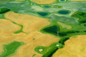
Hummocky landscapes, also called knob and kettle, are characterized by short, relatively steep slopes with numerous small potholes or wetlands. With increasing size of farm machinery, field operations such as tillage, seeding, and harvesting have become increasingly inefficient due to fragmentation. At the same time various incentive programs have targeted these landscapes for conversion to perennial forage, to provide improved upland habitat for waterfowl. As a result these landscapes have been increasingly converted to perennial forages that are used primarily for livestock grazing or forage production.
4. Gently Rolling Landscapes
Gently rolling landscapes are characterized by longer, gentler slopes; and fewer but larger and shallower wetlands. Shorelines and specific zones within the riparian area may be less defined as these may change considerably, depending on the degree of flooding. These wetlands and the adjacent uplands may be quite challenging to manage for agricultural production, as the aerial extent of flooding and soil saturation can vary tremendously over time.
5. Floodplains
Floodplains are typically flat valley bottoms that periodically flood when flowing waters from streams and rivers overflow their banks. Normally, floodplains are not considered wetlands, however, low lying areas within a floodplain that hold water after the stream or river flows subside could be considered as such. Floodplains can also be somewhat challenging to manage depending on the variability of flooding events.
Upland Management Impacts on Wetlands
The impact of upland management primarily involves the effect of different vegetation types and their management on hydrologic processes that influence the amount and quality of water entering wetlands. Wetlands are recharged with water primarily through surface runoff, but also through groundwater discharge, wind blown snow deposited into the wetland, and by direct precipitation on the wetlands. Across the Canadian prairies typically 80% of annual runoff is generated from snowmelt, even though snowfall accounts for only one-third of annual precipitation. (Source: Fang, 2007). The higher tendency for snowmelt to runoff is due to reduced infiltration associated with frozen soils, which usually stay frozen until after most of the snow has melted. Prairie wetlands would not exist without the addition of water from the surrounding uplands.
1. Type and Amount of Vegetation
There are a number of ways that vegetation impacts hydrologic processes. First of all, the increasing amount and roughness of surface cover will reduce snow drifting and water runoff, and increase the infiltration rate of precipitation and snowmelt at the soil surface. Secondly, the type of vegetation may influence the amount of cracks and macro pores that allow for increased infiltration. Thirdly, different types of vegetation have varying abilities to extract soil moisture. Perennial forages extract more moisture than annual crops in fall prior to winter freeze up. The net result of macropores and less soil moisture is increased infiltration and reduced runoff the subsequent spring compared to annual crop stubble. Long-term studies of wetlands at the St Denis National Wildlife Area in Saskatchewan showed that conversion of uplands to undisturbed grass resulted in almost complete drying out of small wetlands within the grassed fields (van der Kamp et al., 1998).
2. Fallow
The greatest land management impact on the fate of snow is the practice of fallow. Typically on fallow land, a much higher percentage of snowmelt succumbs to runoff than infiltration. Fallow soils tend to be moist or saturated entering the winter period, making them highly impermeable, particularly when frozen.
Fallow fields also experience the greatest amount of snow transport via wind drifting. Snow tends to accumulate in low lying areas or around shelterbelts, but a considerable amount may be lost to sublimation before it gets there. Sublimation involves the transformation of solid snow crystals directly to water vapour in the atmosphere, without an intermediate liquid phase.
Since the early 1970's, the amount of fallow has gradually decreased, so these impacts are declining over time (Source: Statistics Canada)
3. Conservation Tillage
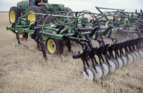
In semi arid regions conservation tillage on annual cropland will result in improved infiltration and reduced runoff due to increased crop residue, soil organic matter and formation of macro pores. Eliminating fall tillage helps to maintain standing stubble which reduces snow drift. These practices also result in lower water erosion and reduced infilling of wetlands by sediment. Reduced runoff and sedimentation will also help to reduce movement and deposition of dissolved and sediment bound nutrients, pathogens, and pesticides into water bodies.
However, greater concentration of nutrients close to the soil surface due to lower soil disturbance and crop residue conservation may result in increased amounts of soluble phosphorus in runoff. Also, in more humid environments conservation tillage may result in higher soil moisture levels entering the winter period, resulting in slower infiltration and increased snowmelt runoff in spring.
4. Nutrient Management
The timing, rate, and method of application of manure and fertilizer can have a significant impact on the risk of nutrient movement from upland areas into water bodies. In most cases practices that maximize efficiency of crop nutrient uptake also result in the lowest risk to the environment.
However, there are some current practices that may result in high nutrient loadings in upland areas.
- manure application rates in excess of crop requirement, often adjacent to intensive livestock operations
- fall application of fertilizer or manure
- high density winter feeding of livestock in open fields
Depending on hydrologic factors relating to soil, landscape, and climate features these excess nutrients may end up in wetland areas. Increased nutrient levels in wetlands do not usually threaten its survival, but may impact its function such as its usefulness as a source of drinking water for many species.
5. Upland Management Impacts on Waterfowl Habitat
In addition to the hydrologic impacts already discussed, upland management also affects waterfowl habitat directly through impact on nesting success. Spring tillage has the greatest negative impact in disturbing nests before young birds have left. This disturbance progressively decreases as one moves to annual crop systems that involve conservation tillage and fall seeded crops, then to delayed cut hay and grazed pasture, and finally idle perennial vegetation.
Specific Land Management Practices Near Natural Wetlands
As a general rule wetlands should be maintained or restored as natural wetlands, and the surrounding upland should be managed as perennial pasture or hay, or annual crop production. However, more careful consideration is needed for areas that are transition between wetland and upland.
1. Restoration of Natural Wetlands
Wetlands that have been drained and used for crop or forage production often still have viable "seed banks" of native species, even after years of cultivation (Source: Rosberg, 2001). Therefore, if the area has not been earth filled, one may only need to restore the original water level. This may be as simple as raising or plugging the surface outlet.
Natural re-establishment of native species may take some time, and may involve a transition period where certain undesirable plant species may have negative impacts on surrounding upland, such as increased weed control costs. Over time there should be a shift to a more stable species composition that has fewer upland impacts.
2. Perennial Forages
Annual crop production should be limited to areas that dry up in time for spring seeding most years, and are not susceptible to ponded water after seeding. Areas too wet for annual crops may be suited to flood tolerant perennial forages. Duration of flooding tolerance varies with forage species, as shown in Table 1.
Note: Some of the content is wider than usual.
| Soil Zone - Brown | Soil Zone - Dark Brown | Soil Zone - Black | Soil Zone - Gray | |||||||||
|---|---|---|---|---|---|---|---|---|---|---|---|---|
| 1 - 2 weeks |
2 - 5 weeks |
> 5 weeks |
1 - 2 weeks |
2 - 5 weeks |
> 5 weeks |
1 - 2 weeks |
2 - 5 weeks |
> 5 weeks |
1 - 2 weeks |
2 - 5 weeks |
> 5 weeks |
|
| Alkali Saltgrass | X | X | X | X | X | X | X | X | ||||
| Creeping Foxtail | X | X | X | X | X | X | X | X | ||||
| Meadow Foxtail | X | X | X | X | X | X | X | X | ||||
| Reed Canary Grass | X | X | X | X | X | X | X | X | ||||
| Slough Grass | X | X | X | X | X | X | X | X | ||||
| Birdsfoot Trefoil | X | X | X | X | X | X | ||||||
| Tall Fescue | X | X | X | X | X | X | ||||||
| Alsike Clover | X | X | X | X | ||||||||
| Meadow Fescue | X | X | X | X | ||||||||
| Dahurian Wildrye | X | X | X | X | X | X | X | X | ||||
| Hybrid Wheatgrass | X | X | X | X | X | X | X | X | ||||
| Smooth Bromegrass | X | X | X | X | X | X | X | X | ||||
| Tall Wheatgrass | X | X | X | X | X | X | X | X | ||||
| Slender Wheatgrass | X | X | X | X | X | X | ||||||
| Streambank Wheatgrass | X | X | X | X | X | X | ||||||
| Western Wheatgrass | X | X | X | X | X | X | ||||||
| Alfalfa | X | X | X | X | ||||||||
| Altai Wildrye | X | X | X | X | ||||||||
| Awned Wheatgrass | X | X | X | X | ||||||||
| Canada Wild Rye | X | X | X | X | ||||||||
| Crested Wheatgrass | X | X | X | X | ||||||||
| Hybrid Bromegrass | X | X | X | X | ||||||||
| Kentucky Blue Grass | X | X | X | X | ||||||||
| Meadow Bromegrass | X | X | X | X | ||||||||
| Northern Wheatgrass | X | X | X | |||||||||
| Creeping Red Fescue | X | X | ||||||||||
| Red Clover | X | X | ||||||||||
| Timothy | X | X | ||||||||||
| Cells with an "X" indicate the duration of flooding tolerance (weeks) for specific forage species
Source: Saskatchewan Forage Council |
||||||||||||
Unfortunately, species with highest flood tolerance generally have lower forage value and also lower drought tolerance. These forages, even though able to tolerate lower levels of flooding, are not recommended for areas that flood for less than 2 weeks because there are other species more suited to these areas.
Forage stands in areas with frequent or long duration flooding or soil saturation are often too wet to be accessible for livestock grazing or haying operations. When they are accessible, the forage has often matured to the point that its feed value has significantly deteriorated. Therefore, even though there is potential to grow forages for agricultural production on lands with long duration flooding, practically these areas are more suitably managed as natural wetlands.
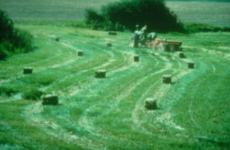
Nevertheless, areas susceptible to moderate flooding may be suited for perennial forage, and in fact be an important source of hay or pasture especially during drought years when upland production is minimal.
3. Salt Tolerant Forages
The degree of salinity also impacts the types of vegetation that can grow. Most annual crops tolerate only slight salinity. Some perennial forages have considerably more salt tolerance, as shown in Table 2. As with flooding, species with high salt tolerance generally have lower forage value.
There are relatively few forage species with both flood and salinity tolerance. Therefore, it is recommended that areas with moderate to high flood duration and salinity be restored and managed as natural wetlands.
| Soil Zone - Brown | Soil Zone - Dark Brown | Soil Zone - Black | Soil Zone - Gray | |||||||||
|---|---|---|---|---|---|---|---|---|---|---|---|---|
| S | M | H | S | M | H | S | M | H | S | M | H | |
| Alkali Saltgrass | X | X | X | X | X | X | X | X | X | X | X | X |
| Altai Wildrye | X | X | X | X | X | X | X | X | X | X | X | X |
| Duhurian Wildrye | X | X | X | X | X | X | X | X | X | X | X | X |
| Hybrid Wheatgrass | X | X | X | X | X | X | X | X | X | X | X | X |
| Tall Wheatgrass | X | X | X | X | X | X | X | X | X | X | X | X |
| Russian Wildrye | X | X | X | X | X | X | X | X | X | |||
| Tall Fescue | X | X | X | X | X | X | ||||||
| Creeping Foxtail | X | X | X | X | X | X | X | X | ||||
| Crested Wheatgrass | X | X | X | X | X | X | X | X | ||||
| Intermediate Wheatgrass | X | X | X | X | X | X | X | X | ||||
| Pubescent Wheatgrass | X | X | X | X | X | X | X | X | ||||
| Slough Wheatgrass | X | X | X | X | X | X | X | X | ||||
| Smooth Bromegrass | X | X | X | X | X | X | X | X | ||||
| Sweet Clover | X | X | X | X | X | X | X | X | ||||
| Northern Wheatgrass | X | X | X | X | X | X | ||||||
| Slender Wheatgrass | X | X | X | X | X | X | ||||||
| Streambank Wheatgrass | X | X | X | X | X | X | ||||||
| Western Wheatgrass | X | X | X | X | X | X | ||||||
| Birdsfoot Trefoil | X | X | X | X | ||||||||
| Creeping Red Fescue | X | X | X | X | ||||||||
| Meadow Fescue | X | X | X | X | ||||||||
| Alfalfa | X | X | X | X | ||||||||
| Cicer Milkvetch | X | X | X | X | ||||||||
| Hybrid Bromegrass | X | X | X | X | ||||||||
| Meadow Bromegrass | X | X | X | X | ||||||||
| Green Needlegrass | X | X | X | |||||||||
| Blue Grama | X | X | ||||||||||
| Big Bluestem | X | X | ||||||||||
| Cells with an "X" indicate the salinity tolerance (slight, moderate, high) for specific forage species
Source: Saskatchewan Forage Council |
||||||||||||
4. Grassed Waterways
Often much of the surface runoff entering wetlands is through channelized flow. This type of flow also occurs when one wetland overflows resulting in runoff to another wetland downstream. These areas should have a flat bottom with gentle side slopes, stabilized with a sod forming perennial grass. This will ensure that the flow remains in the waterway and does not cause gully erosion and deposition of sediments in wetlands.
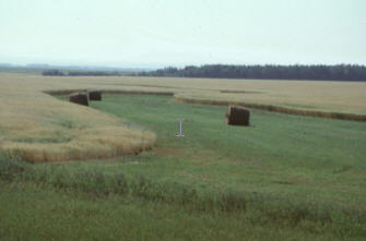
5. Forage Buffer Strips
Natural wetlands contain a variety of perennial plant species in the riparian zone. If the surrounding upland is in annual crop it is often desirable to establish an additional band of perennial forage outside the wetland area. Part of the reason relates to the fact that the outer edge of the riparian zone may vary over time between wet and dry cycles. Therefore, adding a perennial forage buffer helps to ensure that the entire riparian zone remains in perennial vegetation and provides good ecosystem functions. Of the entire wetland area this outermost zone will be the most feasibly used for forage production, because it will be least susceptible to flooding.
The width of this outermost band may vary considerably depending on many factors. In the prairie region forage buffer widths of 10 to 30 meters have been recommended (Source: Huel, 1998). Wider buffers could be rationalized for the following situations or functions:
- gently sloping wetlands that have greater variability in land area susceptible to having excess moisture.
- where grassed waterways or channelized water widens or fans out before entering a riparian area
- increasing the buffers ability to enhance wildlife habitat and biodiversity
- increasing the buffers ability to filter sediment, nutrients, and pesticides
The use of this forage buffer could be hay or pasture, although pasture will be limited to early spring or late fall if the surrounding upland is in annual crop. If high nutrient levels are threatening the wetland area, harvested hay or silage that is transported and fed offsite also provides an extra advantage in helping remove some of these nutrients.
6. Set Back Distances for Crop Inputs
It is generally recommended to keep a setback distance between the edge of a wetland and applications of manure, fertilizer, or pesticides. This reduces the risk of nutrient, pesticide, and pathogen loadings into water bodies. A forage buffer strip is a good land use for a set back area, because it generally does not require nutrient or pesticide inputs to remain productive.
7. Squaring Off Forage / Annual Crop Boundaries
A major consideration in the design of forage buffers and set back distances is to create an annual cropped field that is not fragmented and subject to inefficient field operations through excessive overlap. This can be achieved by including small, irregularly shaped parcels of land adjacent to the wetland in the forage buffer (Source: Gregg). In a field with several wetlands connected by grassed waterways, it may be prudent to expand the forage to the area between the wetlands as well. The feasibility of this practice is also dependant on the ability to utilize the increased forage production.
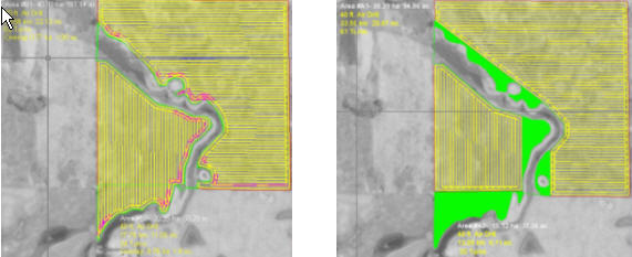
Before
After
Photo: Courtesy the Saskatchewan Watershed Authority.
8. Wetland Consolidation
Some farmers have effectively addressed the field fragmentation issue by draining a number of smaller wetlands into one larger one. The remaining wetland will experience an increase in area and volume roughly equal to the total area of the drained wetlands. However there is usually still a loss of wetland function primarily due to a reduction in wetland shoreline perimeter. Nevertheless, wetland consolidation may be more acceptable if it focuses on draining wetlands with very infrequent flooding, in other words those with minimal wetland function and maximum agricultural production potential. It should be noted that wetlands with short duration spring time flooding have significant function for nesting waterfowl.
9. Converting Entire Fields to Perennial Forage
For fields with excessive fragmentation, it may be more feasible to convert the entire field to perennial forage than establish forage in smaller areas like buffers and waterways. This has already been identified as a priority for hummocky landscapes, but may also be suitable in certain situations for other landscapes. A major factor in this decision is the interest and ability of the producer to make a significant management change from annual crop to livestock production. Often these conversions are most evident when accompanied by changes in land ownership or tenure.
10. Grazing Management
Wetlands can provide significant benefits for livestock production through the provision of forage, water, and shelter. However, without limited or restricted livestock access these areas can become negatively impacted by excessive nutrient and pathogen loadings, and excessive hoof disturbance in saturated zones. A proper grazing management plan which includes practices such as remote offsite watering systems, controlled riparian grazing, and upland portable windbreaks or shelters can help minimize these problems.
11. Trees and Shrubs
Trees and shrubs are a natural part of prairie wetlands. Species like willow and aspen are often found in the riparian zone. These species have considerable flood tolerance. This tolerance is exhibited not only in the ability of individual trees to survive a certain amount of flooding, but also the ability of these species to generate new trees through root suckering. For example, while prolonged flooding lasting for one year or more can kill a stand of aspen within a wetland area, new tree shoots will often emerge upslope of the flooded area.
Trees and shrubs also provide excellent nesting and foraging habitat for many resident and migrating songbirds. In addition other forms of wildlife use these areas as cover and shelter habitat. Beneficial insects such as bees and other pollinators are attracted to these sites.
The use of trees for commercial biomass production has recently gained interest on agricultural land (ie. agroforestry). Planting trees for agroforestry around wetlands may help to extract and remove excess nutrients. Trees may be even more effective than some forages, by using more extensive and deeper root systems to recapture deep leached nutrients.
A major concern with growing trees in this part of the landscape is the risk of flood damage. This depends on the risk of a flood event, the duration of flooding and soil saturation, the flood tolerance of the tree species, and the expected harvest interval of the tree crop. For example, species such as willow that are harvested on a frequent time interval would be considerably less risky than hybrid poplar harvested only after reaching a mature age.
Sustainable Management in the Midst of Variable and Changing Climate
Due to the high proportion of runoff that occurs during snowmelt, wetland water levels typically peak in the spring. Water levels then gradually subside throughout the summer as evaporation and water use by the riparian vegetation become more dominant hydrologic processes. However, intensive summer thunderstorms can quickly refill wetlands.
In addition to annual cycles, there are also multiyear cycles that impact water levels in wetlands. Sometimes these cycles can last for a number of years. These wet and dry cycles pose special challenges for agricultural producers, especially because they are unpredictable. Add to this the risk of climate change and increased climate variability, and these challenges intensify.
Most crops and perennial forage species do not exhibit good tolerance for both flooding and drought. Therefore, there is always a risk of crop failure or forage die back. During longer drying or wetting trends there may be a need to make some land use and management changes to adapt. Decisions to change or not to change involve significant risk as one never knows how long a current trend will last.
The preferred goal is to find an appropriate balance in managing landscapes sustainably for agricultural production while maintaining the landscapes ecosystem functions. The specific practices to achieve this will vary from region to region, farm to farm, and even field to field depending on many factors. Making good management decisions requires a thorough knowledge of these factors, sufficient advance planning, and a patient commitment to carry through despite changing seasonal and year to year circumstances. A degree of flexibility is also required to adapt to longer wetting or drying trends that may require changes in land use or management for a period of years.
References
Canadian Wetland Inventory, (http://www.ducks.ca/cwi/)
Canadian Wildlife Service, The Federal Policy on Wetland Conservation, 1991. Cat. No. CW66-116/1991E ISBN 0-662-18940-X
Cortus, B.G., P.C. Boxall, S.R. Jeffrey, J.R. Unterschultz, 2006. Economics of On-Farm Wetland Drainage in the Prairie Pothole Region of Canada
Dryland Forage Species Adaptation CD, 2007. Saskatchewan Forage Council
Fang, X., A. Minke, J. Pomeroy, T. Brown, C. Westbrook, X. Guo, S. Guangul, 2007. A Review of Canadian Prairie Hydrology: Principles, Modelling, and Response to Land Use and Drainage Change, Centre for Hydrology, University of Saskatchewan
Gregg, N., Determining Options to Lower Mechanical Overlap in Sinuous Riparian Areas, 2007. Prairie Agricultural Machinery Institute (PAMI).
Huel, D., Managing Saskatchewan Wetlands, A Landowner's Guide, 2000. Saskatchewan Watershed Authority
Huel, D. Streambank Stewardship, A Saskatchewan Riparian Project, 1998. Saskatchewan Wetlands Conservation Corporation
Leck, M.A. -1989-: Wetland seed banks. In: Leck M.A., Parker V.T. & Simpson P.L. (Eds) Ecology of soil seed banks 283-304, San Diego, Academic Press.
Statistics Canada, Census of Agriculture, (http://cansim2.statcan.ca/cgi-win/cnsmcgi.pgm?Lang=E&SP_Action=Theme&SP_ID=920)
van der Kamp, G., W.J. Stolte, and R.G. Clark, 1999. Drying out of small prairie wetlands after conversion of their catchments from cultivation to permanent brome grass. Hydrological Sciences Journal, Vol 44, No. 3, 387-397.
Author: Dennis Haak, Soil Resources Division, AAFC-PFRA, September 2008.