
As of June 10, 2025
This report is to provide timely information on regional agroclimate conditions, risks, and impacts across Canada. Reports are produced every four weeks.
National Overview
The most significant climate-related agricultural risks this reporting period are drought conditions in Western Canada.
Low spring precipitation, combined with high winds, have resulted in Severe and Extreme Drought conditions in many parts of Western Canada, with multiple wildfires occurring along the northern agricultural extent of the Prairie Region. At this time, minimal impact to agriculture has been reported due to wildfires.
Above normal temperatures are forecast throughout the country, with the exception of northern British Columbia and Alberta, where temperatures are expected to be near to above normal (compared to 1991-2020 averages). High temperatures combined with low precipitation may worsen drought conditions in parts of Western Canada and the Atlantic Region.
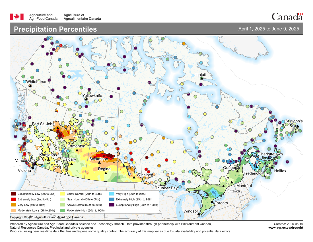
Precipitation Percentiles (April 1 to June 9, 2025)
Precipitation Percentiles from April 1, 2025 to June 9, 2025, high-resolution image (5 MB JPG)
The Alberta/British Columbia Peace Region, southeastern Alberta, northern agricultural regions of Saskatchewan and Manitoba, as well as northwestern Ontario, received very low precipitation in May.
Above-normal precipitation was received in west central Alberta, southeastern Saskatchewan, southwestern Manitoba, and throughout Eastern Canada
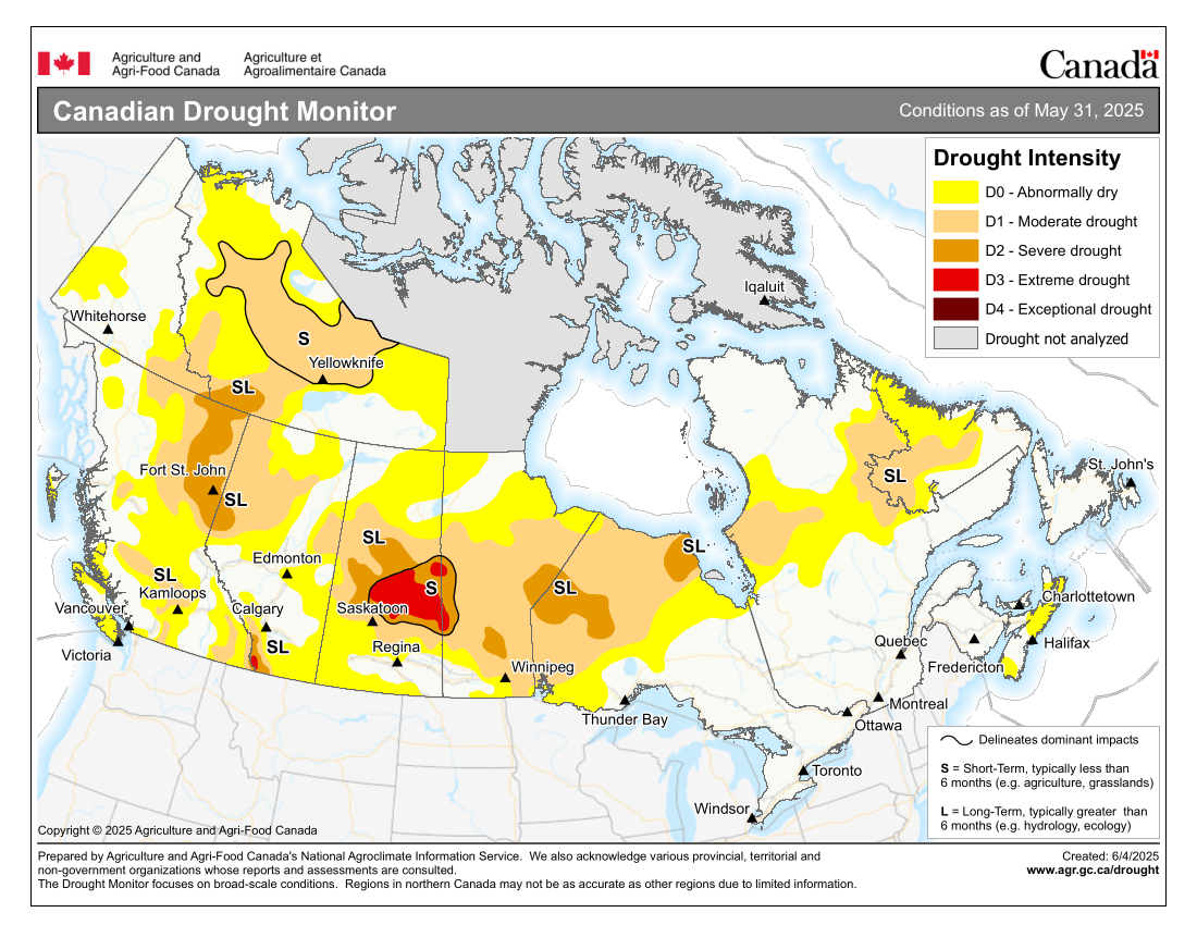
Canadian Drought Monitor (Conditions as of May 31, 2025)
Canadian Drought Monitor, conditions as of May 31, 2025, high-resolution image (5 MB JPG)
At the end of May, 55% of Canada was classified as Abnormally Dry (D0) or in Moderate to Extreme Drought (D1 to D3), including 53% of the country's agricultural landscape.
Areas of Extreme (D3) Drought conditions emerged in central areas of Saskatchewan and west central Manitoba. Exceptionally low spring precipitation and above-normal temperatures through May resulted in poor soil moisture, poor pasture and crop conditions, and well above-normal wildfire activity. Southwestern Alberta continues to be in Severe (D2) or Extreme (D3) Drought. While there was significant expansion in drought overall, some regions of the country saw improvement including coastal British Columbia, southeastern Saskatchewan, southern Ontario, southern Quebec, and Nova Scotia.
Regional Conditions
- British Columbia
- Much of British Columbia received near- or above-normal precipitation during this reporting period. The exception was the Peace Region, where significantly below-normal spring precipitation has led to poor moisture conditions.
- Warmer than normal temperatures and early snowmelt have accelerated drying, which increased drought and forest fire potential, particularly in the northeast.
- Fruit and vine crops are generally in good condition. However, in the southern Okanagan there have been reports of plant stress and tree wilting due to ongoing drought.
- In the Peace Region, seeding progressed well this spring, due to warm spring temperatures and dry conditions. However, the continued lack of moisture has resulted in poor soil moisture and stress on emerging crops. Cattle producers are also facing challenges, including difficulty accessing feed and the need to reduce herd sizes.
- Alberta
- Over the past 30 days, temperatures have been generally above normal across the province, particularly in western regions. Precipitation levels were near normal across most of the province, except in the Peace Region and southeastern areas. Conditions are very dry in the Peace Region, with reports of slow or spotty crop emergence.
- As of June 3, the seeding of major crops across the province is complete, slightly ahead of the five-year average. Provincial crop development reports indicate that the 2025 crop is progressing well, with 83% of all crops emerged.
- Pasture conditions and tame hay growth are both rated as 59% good to excellent.
- Grasshopper activity has been observed in some fields.
- Saskatchewan
- Well below-normal precipitation was received across western and central areas of the province over the reporting period, with drought intensifying in northern agricultural regions. Above normal precipitation was received in the southeast, improving drought conditions. Temperatures trended above normal across much of the province.
- Seeding is complete. However, cropland topsoil moisture is declining due to reduced rainfall and warm temperatures, with over half of producers reporting inadequate moisture. Although most crops are rated in fair to good conditions, precipitation is needed to sustain crop development.
- Producers report generally good crop emergence across the province, although some later-seeded crops have shown spotty development.
- Dry conditions, wind and heat across the province have resulted in minor crop damage particularly along the northern agricultural extent.
- One third of hayland and pasture producers have reported experiencing inadequate soil moisture.
- Manitoba
- Since the last report, Manitoba has received below-normal precipitation across eastern and northern portions of the agricultural extent. Above-normal precipitation was received in south central and southwest portions of the province. Severe and Extreme Drought conditions have developed along the Saskatchewan border and in northern portions of the Interlake Region.
- As of June 3, provincial seeding progress is 95% complete, significantly ahead of the five-year average. The majority of Manitoba is reporting optimal to surplus soil moisture conditions.
- Winter wheat and fall rye survival and growth have been reported to be very good. Spring seeded crops are beginning to emerge.
- On-farm water storage is near or below normal. Some rivers and lakes have dropped below their typical range for this time of year.
- Dugouts are in better condition than expected given the low levels of precipitation. However, inadequate water availability for livestock in the La Pas and Swan River regions have been reported.
- Ontario
- Most agricultural regions of the province have received above-normal precipitation since the last report. However, northwestern Ontario received extremely low precipitation. Temperatures were below normal across the province.
- Below-normal temperatures in April and May have slowed crop emergence. There are some reports of corn yellowing from cold temperatures. Crop emergence is rebounding with recent warmer temperatures. Plant stands are generally acceptable, but are slightly lower than in recent years.
- Soybean planting is largely complete on lighter textured and well-drained soils. However, planting is still underway on heavier soils and in regions continuing to receive sporadic rainfall.
- Quebec
- Although temperatures averaged to near normal during the reporting period, the month was characterized by alternating periods of hot and prolonged cold weather.
- Precipitation was above normal in the southern, central and eastern regions of the province, while the western regions recorded below-normal precipitation.
- Frequent rainfall events caused significant delays in corn and soybean seeding, particularly on heavier soils. Subsequent cooler temperatures further delayed or hindered crop emergence. As a result, yield potential for corn, soybeans and spring cereals may be affected.
- The first cut of hay is underway and winter wheat has reached the heading stage. Both are reported to be in good condition.
- Planting is underway in the horticultural sector. Delays in planting and regrowth of certain crops have been reported. The situation does not appear to be widespread for all horticultural crops.
- Atlantic Region
- Frost has been reported in low-lying areas, though no impacts have been noted at this time.
- Many parts of the Atlantic Region received substantial precipitation, leading to the lifting of burn bans in some areas. All seeding has been completed across the region.
- First-cut forage has been completed, and yields are reported as very good.
Forecast
- The June forecast is for above-normal temperatures across much of the country, with the highest probability of above-normal temperatures being forecast for southeastern British Columbia, Manitoba and Eastern Canada. Near-average or above-average temperatures are forecast for northern British Columbia and northwestern Alberta. June precipitation is expected to be below normal across agricultural portions of Western Canada and the Atlantic Region. While above-normal precipitation is expected from southeastern Manitoba through northwestern Ontario and also across southern Ontario and southeastern Quebec.
- The seasonal forecast for June through August indicates above-normal temperatures across the country with the highest probability found in southern British Columbia, Manitoba and across Eastern Canada. The seasonal precipitation forecast indicates drier than normal conditions across southern portions of British Columbia and Nova Scotia.
- The persistence of warmer than normal temperatures could result in accelerated field work and seeding activities, but more moisture is needed in regions impacted by drought in order to support crop emergence and pasture growth.
This report was created with help from our network of Agroclimate Impact Reporter volunteers. Each month, they help us report on current conditions and weather-related risks to Canada's agriculture sector. Join the network if you are interested in becoming an Agroclimate Impact Reporter.