
Summary
- Soil erosion — the movement of soil from one area to another — is a significant threat to Canada's agricultural soils.
- It can decrease agricultural productivity, lower profits and reduce water quality.
- The Soil Erosion Risk Indicator measures the risk of soil erosion from wind, water and tillage. It also shows how soil erosion risk has changed over time.
- Canada's soil erosion risk has declined greatly since 1981 because of increased use of conservation tillage and decreased use of summerfallow.
- However, risk has only slightly decreased since 2016 because of a levelling off of these improvements.
- Methods to reduce the risk of soil erosion include further increases in conservation tillage, and wind and water control measures, especially in at-risk areas such as hilly landscapes.
Soil erosion in Canada: why does it matter?
Soil erosion — the movement of soil from one area to another — is a significant threat to Canada's agricultural soils. Erosion removes topsoil, reduces soil organic matter and contributes to the breakdown of soil structure. These factors reduce soil fertility and movement of air and water into and from the soil surface which can reduce crop yield. In fact, crop yield from severely-eroded soils can be much lower than from non-eroded soil in the same field.
Soil erosion can also cause significant environmental impacts through runoff transported by agricultural drains, ditches and waterways. This can lead to water quality issues such as increased water cloudiness (turbidity), sedimentation, and accumulation of nutrients, pesticides, pathogens and other substances.
Soil erosion also has significant economic impacts. The annual cost of soil erosion — from reduced crop yield alone — was estimated to be $3 billion per year in 2011. This was equal to 10% of the total value of crop production. It is also expected that climate change could increase the risk of soil erosion because of increases in dry soil conditions leading to low soil cover and exposed soil.
The Government of Canada reports on soil erosion on farmland. This information helps Canadians determine if Canada's farmlands are healthy and where improvements to farming practices need to be made.
What causes soil erosion?
Soil erosion occurs on agricultural soils through three main processes: wind, water and tillage erosion. Wind and water erosion occur naturally in the environment. However, these processes can be accelerated by farming activities such as summer fallow and annual crop production. Wind erosion is a concern in many areas of Canada, however, the greatest risk of wind erosion occurs in the Prairies. This is caused by the region's hot, dry climate and large areas of cultivated land with little protection from the wind.
Tillage erosion is the movement of soil from hilltops to the base of hills. It is most severe on land that has many short, steep slopes and in areas where intensive cropping and tillage practices are used. Tillage erosion can also make the impact of wind and water erosion greater. It exposes the subsoil that is often more sensitive to wind and water erosion processes. It also delivers soil to the areas of the landscape where water erosion is most intense.
Farming decisions can influence erosion in different ways, so effective erosion control requires solutions that consider all erosion processes. Shelterbelts and water diversion terraces can reduce wind and water erosion, however, the addition of these obstacles at field edges can increase soil lost by tillage erosion. Equipment matters as well - a chisel plough leaves more crop residue on the soil surface than the moldboard plough. The higher crop residue levels can provide protection against wind and water erosion. However, the chisel plough also can move soil farther than does the moldboard plough leading to more tillage erosion. High-disturbance direct seeding (used in some no-till cropping systems) can cause as much tillage erosion as the moldboard plough because it moves soil large distances.
The Soil Erosion Risk Indicator
The Soil Erosion Risk Indicator measures the risk of soil erosion caused by wind, water and tillage. It also measures whether this is changing over time. It considers climate, soil characteristics, topography and the type of farming practices employed (gathered from Census of Agriculture data). Soil erosion is estimated using landform, soil and topography data from the National Soil Database. It is calculated as soil loss across all segments of a landform (upper slope, midslope, lower slope and depressions). Soil loss from wind and tillage are greatest on the upper slopes and losses from water erosion are greatest on midslopes.
The amount of soil loss for each period is reported in five classes: very low, low, moderate, high and very high. Areas in the very low risk class are considered capable of maintaining long-term crop production and environmental health. Areas in other classes are at some level of risk and require soil conservation practices to support long-term crop production and environmental health.
The Government of Canada calculates the Soil Erosion Risk Indicator every five years. It helps the Government evaluate how soil erosion on farmland is changing over time and where changes to farming practices are needed.
Soil erosion in Canada — current state and the change over time
In 2021, the state of the environment from the standpoint of the risk of soil erosion on farmland in Canada was 'desired.' The cropping system leading to the highest risk of soil erosion in Canada is potato production in the Maritimes because it requires intensive soil tillage. Soil erosion risk is also high for corn and soybean systems that use conventional tillage. However, both corn and soybeans have the potential to be grown using conservation tillage. In terms of landforms, the highest risk of soil erosion is associated with slopes of a gradient of 10% or more. This is especially the case in Eastern Canada, where climatic conditions increase the risk of water erosion.
Soil erosion is of most concern where at-risk crop types are grown in high-risk landscapes. This is the case for a much of the cropland in southern Ontario and in Atlantic Canada. However, there are areas in every province with high soil erosion risk, including the steep slopes of the Hand Hills region of southern Alberta, the very dry and loamy soils of windy southern Saskatchewan, and the steep slopes along the Manitoba escarpment.
Overall, the risk of soil erosion on Canada's cropland declined between 1981 and 2021. Over this period, cropland area in the High and Very High risk classes decreased from approximately 13% to 3%. At the same time, cropland area in the very low risk class increased from approximately 38% to 78%. This was caused, mainly, by increased use of conservation tillage (especially no-till systems) and decreased use of summerfallow in the Prairies.
Since 1981, the amount of Canada's cropland using conservation tillage, particularly no-till, increased from less than 2% to 30%. It is now the most common tillage practice in the Prairies, used on 76% of cropland in Saskatchewan and 66% of cropland in Alberta. Although tillage intensity has decreased for most crop types, the adoption of no-till in cereal crops has had the greatest influence on soil erosion. This is because such a large percentage of cropland is devoted to cereal production. Over the same period, the use of summerfallow decreased from 13% to less than 1%.
Changes in the type of crops grown had a smaller impact on erosion risk. Since 1981, the amount of cropland used for intensive-tillage crops (such as corn, potatoes and beans) increased from 5% to 22%.
Despite overall improvement since 1981, soil erosion risk increased, slightly, between 2011 and 2016 and decreased only slightly in 2021. This suggests that reductions in erosion risk due to ongoing practice change might have levelled off.
How can soil erosion be reduced?
The effectiveness of farming practices to reduce soil erosion depends on farming system, weather and land characteristics (such as soil texture and slope).
All forms of soil erosion can be reduced by using less-intensive tillage on cropland. This reduces soil movement. It also preserves more crop residue on the soil which protects soil from the erosive forces of wind and water.
To reduce soil erosion from water:
- Use conservation tillage
- Plant row crops across the slope
- Use strip cropping
- Inter-seed row crops with other crops
- Grow cover crops
Where the risk of water erosion is very high, alternative practices could be required:
- Establish terraces to reduce slope steepness and length
- Establish permanent berms, or diversions, running along contours
- Convert land to perennial cover
- Construct grassed waterways or erosion control structures to address gully erosion
To reduce soil erosion from tillage:
- Focus efforts on hilly landscapes that are most prone to erosion
- Use no-till practices to grow crops or grow crops that require no tillage (such as forage)
- In cropping systems that require soil disturbance (such as potato production), use tillage implements that move less soil and move it over a shorter distance.
- Where possible, use contour tillage instead of tilling up and down slopes. Use a moldboard plough that throws the furrow upslope.
Reducing or stopping soil erosion does not immediately restore soil health and productivity. Sometimes it can take decades or centuries for highly-eroded soils to become productive and profitable again. Soil-landscape restoration can be used to quickly restore eroded soils. This involves collecting rich topsoil from areas where past tillage erosion has caused soil to accumulate (such as the base of hills) and moving it upslope to areas of soil loss. In some areas this practice has been shown to increase crop yields by as much as 20-50% and to increase crop biomass by up to 95%.
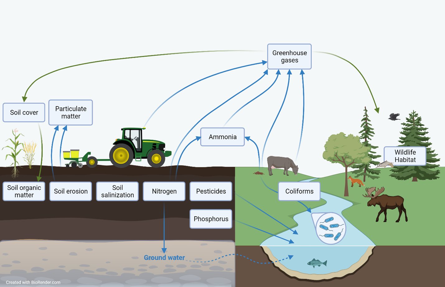
Description of the image above
An infographic showing an agricultural landscape with crops, a tractor, soil and grazing livestock adjacent to a natural landscape with a watercourse, forest and wild animals. Info boxes are placed to show to which element of the landscape each agricultural sustainability indicator pertains. Arrows connect some of the info boxes to show interrelationships. One info box is present for each of the following indicators: Soil cover, particulate matter, soil organic matter, soil erosion, soil salinization, nitrogen, pesticides, phosphorus, ammonia, greenhouse gases, coliforms and wildlife habitat.
Agriculture and Agri-Food Canada's agri-environmental indicators (AEIs) provide a science-based snapshot of the current state and trend of Canada’s agri-environmental performance in terms of soil quality (soil organic matter, soil erosion, soil salinization), water quality (nitrogen, pesticides, phosphorus, coliforms contamination), air quality (particulate matter, ammonia, greenhouse gas emissions) and farmland management (agricultural land use, soil cover, wildlife habitat). While indicator results are presented individually, agro-ecosystems are complex, so many of the indicators are interrelated. This means that changes in one indicator may be associated with changes in other indicators as well.
Additional resources and downloads
Discover and download geospatial data related to this and other indicators